I saw this on Twitter Wednesday morning.
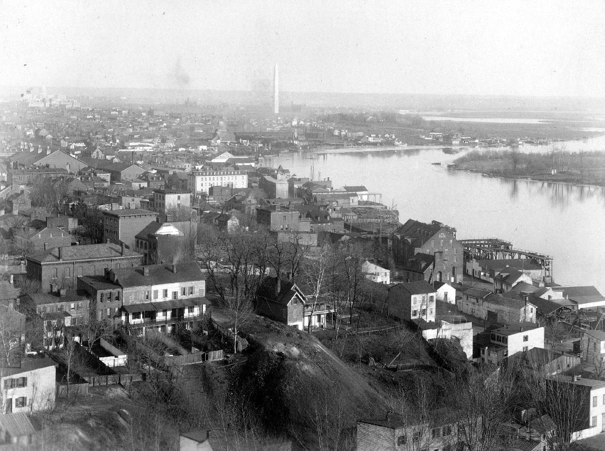
It’s a photograph from the Georgetown University archives of Georgetown in 1890, looking out at the Washington Monument, taken from Georgetown’s Healy Hall.
In the fall, I wrote about digging into a street map of Washington, circa 1883 and using it to find where my ancestors lived in Washington between the 1860s and the 1880s. While I’d walked, a number of times, the area around the Navy Yars where they lived prior to 1885 (or so), but it wasn’t until last September that I walked the area in Georgetown where they lived circa 1886. The Gardners lived a block from the C&O Canal, two blocks from the Potomac waterfront.
Seeing these locations on a map, with buildings, gave me a very different view of where they lived than I would get from the ground level today. And a contemporaneous photograph, taken from a vantage point high above Georgetown, gives me an entirely different perspective than a map.
Intuitively, knowing from the map the location where they lived and having walked those streets, I knew the photograph had a very good chance of showing the building where the Gardners lived a few years earlier. I belived, when I was there in September, that their home was on the north side of what’s now M Street NW (then Bridge Street), but based on maps from the time that mark the properties, I now believe that they lived on the south side of the street, either where the Ukrainian embassy is now (specifically, the eastern half of it) or the building adjacent.
Comparing the photograph to old maps, they would have lived in the photograph’s field of vision. But was the building itself visible?

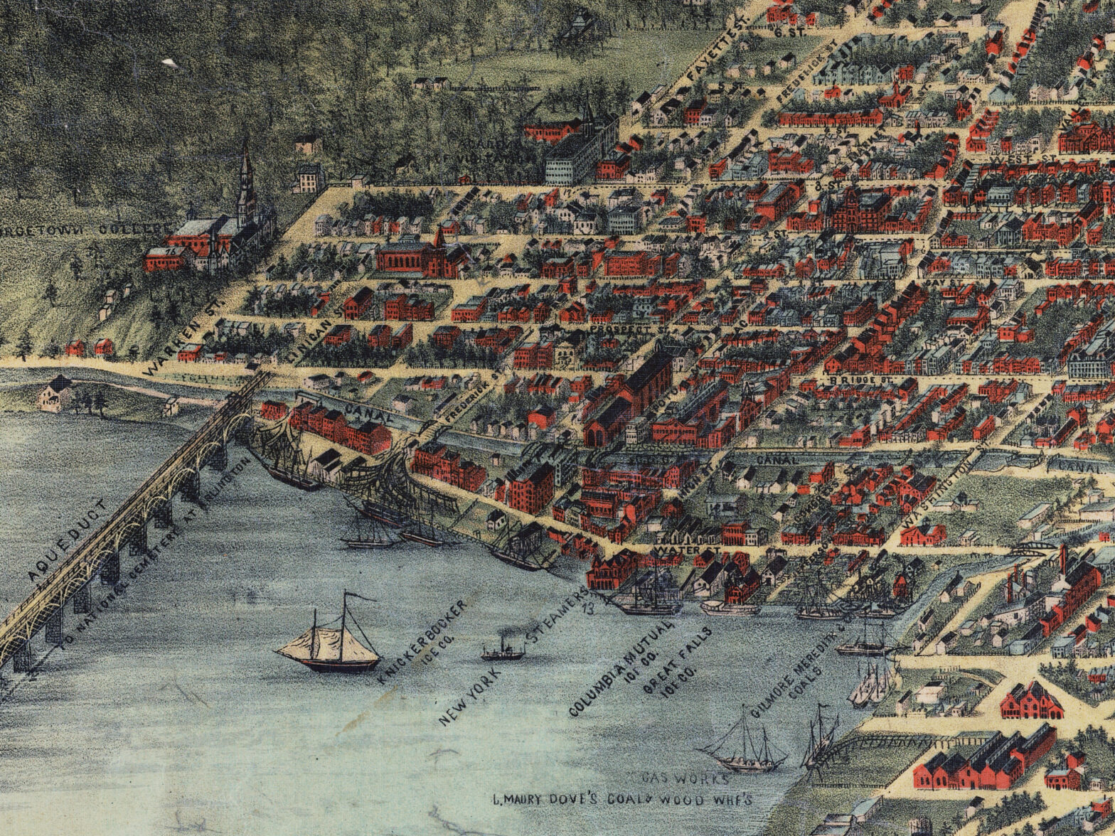
Wednesday morning, I said, “Absolutely. I have no doubt.” I flipped back and forth between the Sachse birds-eye-view map of Washington and the Georgetown University photograph, identified the streets, identified the canal, and by a process of Sherlockian deduction said, “That’s the building.”
By Friday, I began to doubt myself. There were buildings on the map that I couldn’t identify in the photograph. Where’s Grace Episcopal? There were buildings in the photograph that I couldn’t identify on the map. What was that church in the distance along what should be M/Bridge Street? What about those large warehoues running east-west? Yes, the map was from six or seven years before the photograph. Yes, the map is somewhat fanciful. There are going to be differences. Yet… yet… The doubts grew. And when I started to annotate the photograph, those doubts stopped me in my tracks.
Last night I sat down with the map and the photograph. I was going to solve this. I was determined to work the problem.
I started with the block of rowhouses at lower right, their rears to the photographer in Georgetown’s Healy Hall. Opposite them on the street, a large, dark building oriented on the north-south axis. Could I match this to anything on the map?
I could! A block of rowhouses, running north along Finigan Street’s western side, and opposite them, on the northeast corner of Prospect and Finigan, a large, dark red building running north-south.
I had identified Prospect Street, and I had identified Finigan Street in the photograph, and they were marked on my map. The map makes Georgetown out to look flat as a pancake, and it’s nothing of the sort. Prospect Street, as you can see in the photograph, goes past those rowhouses and tumbles over a steep incline.
Heading east, the next north-south street is Fayette Street, and after that is Frederick Street. The Gardners, assuming I’m reading the old property maps correctly, lived not at the corner of Bridge Street (one south block of Prospect) but one house east of it.
Can I identify Fayette Street…?
Alas, no. Fayette dead-ends at the canal, and the buildings along the waterfront and the canal are of no help.
What about the bridge I see across the canal? That could be the bridge across Frderick Street, or it could be the bridge across Market Street one block to the east. Could I figure this out? It appears to be close to the Potomac River. According to the map, the bridge across the canal on Frederick Street is close to the river, while the bridge on Market Street is not.
One problem, and the reason for my doubts last night, is that the map shows extensive warehoues on the strip on land between the canal and the river, many of them three or four storeys tall, and the photograph does not. However, the warehoues that are along the river near that bridge most nearly correspond to the warehouses I see in the map. The map shows a series of tall warehoues with peaked roofs that are oriented somewhat east-west, with a series of white warehoues oriented north-south between them and the river, between the Aqueduct Brudge that connects to Finigan Street and the bridge across the canal at Frederick Street. What appears to the outlet of the Aqueduct Bridge onto Finigan Street is at the right hand edge of the photo, and the buildings around it on the map match the photograph.
Given that, Fayette Street deadends north of that bank of red warehoues, and it’s the hilly geography of Georgetown that prevents me from identifying it, but it would be near the white building with the asymetrical roof near center right, and I can locate that building on the map on Bridge Street midway between Finigan and Fayette.
So, now I’ve identified Bridge Street and Frederick Street, and I know roughly where Fayette Street is.
The map tells me that Bridge Street was, circa 1883, undeveloped on its north side between Finigan and Frederick as it shows only trees. It appears to me that was still true in 1890, for there’s a lot of trees along Bridge Street.
And then I get lost again. The things I know begin to confuse me.
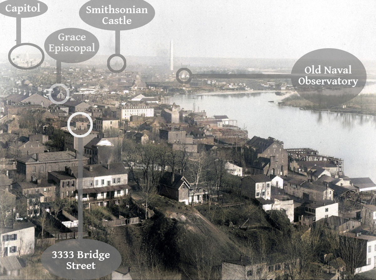
It’s when I take another look at the photograph that I find myself again. I take a look look at the church that’s center-left. I can’t identify it on the map. There’s a church in the vicinity with a steeple that faces east, but this church has a steeple that faces west, and the only church even roughly in the vicinity with an east-facing steeple is Grace Episcopal, which may have been designed by James Renwick. And when I compare the church in the photographs to photographs online of Grace Episcopal, I begin to really think that church is Grace Episcopal, even though it seems like it’s too far inland.
I go back to the map, study the map some more, and I begin to see the mistake I made on Wednesday in the image.
The building that I thought was at the southeast corner of Frederick and Rridge, the building that I had identified as the one where the Gardners lived or adjacent to it, wasn’t. It was on Fayette, probably overlooking the C&O Canal, and what I thought was the canal was not, in fact, the canal. And Frederick Street was further from the photographer that I thought it was. The camera angle was a little more southerly than I thought it was as well, which meant that the apparently angle of Bridge Street was not what I had thought it was. And the long building that runs along the west side of Potomac Street, the street east of Market, on the map south of Bridge, which I couldn’t find in the photograph, turns out to be there, after all. It’s just more to the left than I thought it was.
Then angles made sense, and I could make reasonable guesses at some of the buildings on the photograph and match them to buildings on the map. There are some in the photograph that I can’t, and there’s one that still throws me off, but the map predates the photograph by about seven years, and, as I said, it’s a very stylized representation.
From that, if this lines up with this, and that lines up with that, and that’s what I think it is, and that building is there, then that would probably be the place.
Going by Boyd’s City Directories of the time, they didn’t live here long. Maybe no more than a year. Why they moved from the Navy Yards area to Georgetown, trading the banks of the Anacostia for the banks of the Potomac, and then from there to Baltimore in 1886-7 I don’t know. My guess is that William, my great-great-grandfather, was waiting for his mother-in-law, the mother of his first wife, to die. She did so in 1886, in her mid-eighties, and is buried in Congressional Cemetery with her daughter, William’s first wife. Now aged sixty, with nothing tying him and the family to Washington and no frail, elderly mother-in-law to look after, moving to Baltimore, where he had lived before the Civil War and where his second wife Susan, my great-great-grandmother, came from, the family moved. Do I have any evidence of this? No. Is it a plausible theory based on what I know they did? Yes.
Have I identified the building where the Gardners lived in 1886? Not definitively. I can identify Bridge Street, and I believe I’ve found Frederick Street, and if I have them then I have where they lived on the south side of Bridge Street. They may be a little more up and to the left. At the very least, whatever my doubts about an exact identification, I know I’ve identified the general area. And that’s good enough.