Yesterday afternoon, Howard Weinstein shared an interesting find on Facebook, E. Sachse, & Co.’s 1868 map of Baltimore City. Weinstein is writing an historical novel set in Baltimore about a decade later, and he said it would be helpful in his research, and perhaps to others as well.
I had ancestors in Baltimore in 1868 — my great-great-grandmother Susan and her father Thomas Feenhangen — so I pulled up my Ancestry account to get some addresses, downloaded the full-size image, and went to work.
There were two things I found — the location of my great-great-great-grandfather’s house in 1868 and the church in Fells Point where my great-grandparents as well as my great-grandfather’s sister and her second husband might have been married thirty-ish years later.
We’ll start with the church, which I’ve circled.
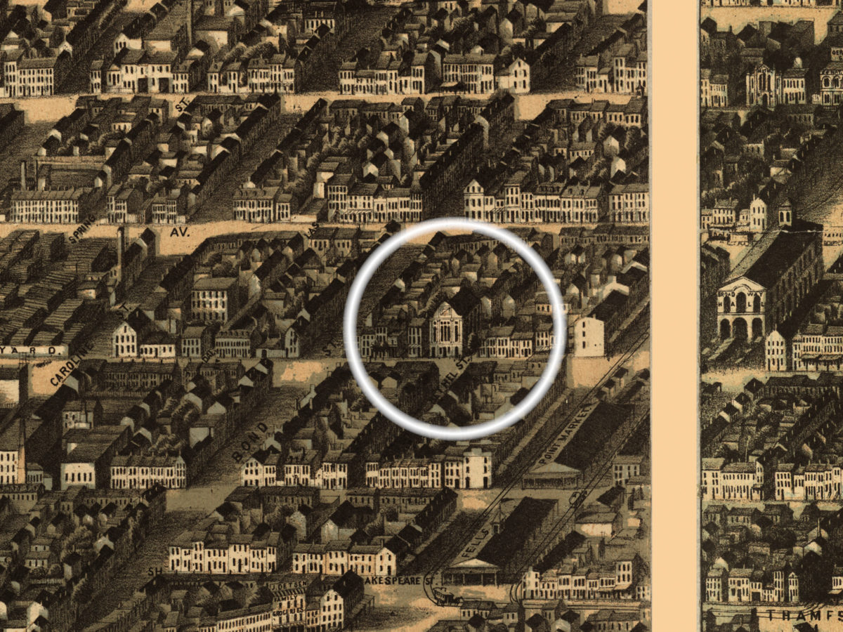
Seaman’s Bethel Church stood at the corner of Aliceanna and Bethel Streets. I’m not sure when it was torn down, but I’ve been unable to locate any photographs of it. (Update: I have found one, dating to the 1920s.) In April 1900, Isabelle Boswell married her second husband, William Krauch, and the minister of record was Frank D. Reynolds, whose church was Seamen’s Bethel. Later that year, in November, Isabelle’s brother Allyn Gardner married Caroline Moore, and Frank D. Reynolds was also the minister of record.
In 1900, the Allyn and Isabelle lived near one another in Federal Hill. Between 1890 and 1920, my great-grandfather Allyn, his mother, his siblings (Isabelle, Maurice, Arthur, possibly Henry, and, after 1910, Ella), and even his siblings’ adult children, lived along Hanover or Charles Streets, if not next to one another, then certainly within a few blocks of walking distance. That Isabelle and Allyn were married by a minister whose church was in Fells Point has puzzled me, as there were closer churches, but their mother Susan had grown up in Fells Point, Seaman’s Bethel catered to the men who worked the seas, her father was a sea captain, and Seaman’s Bethel could easily have been the church their mother had known for all of her Baltimore life. Susan could have insisted that some of her children be married there — or at least have the minister from there perform the ceremony. Alternatively, Isabelle’s second husband was from the eastern side of Baltimore (he and a daughter from his first marriage are buried at Mt. Carmel on O’Donnell Street, and I did not locate them when I visited Mt. Carmel earlier in the year), he chose the venue and the minister, and when it came time for Allyn to marry Carrie seven months later, my great-grandfather could have said, “Well, Frank D. Reynolds seems like a nice enough bloke, so that’s who we’ll use.”
In any event, having never seen what Seaman’s Bethel looked like, since it no longer exists and there are no photographs, I was excited to find it on the map. Its facade is very church-like, as one would expect..
On the second picture, a wider picture that shows more of the city, in addition to circling the church (sort of right-center), I circled where Thomas and Susan lived circa 1868, 62 S. Anna Street (to the right).
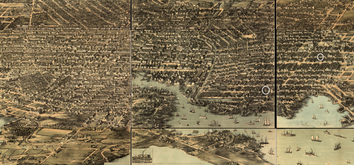
Susan’s first marriage was to a man named Henry Hardy, and she had two sons (that I know of) — Thomas (born 1861, presumably named for her father) and Henry (born 1865). Henry Hardy was a pilot; in other words, he worked on the water, guiding ships into dock. He may have worked for Thomas Feenhagen, he may not. I honestly don’t know. I’m not even sure when he died, but it was sometime between 1867 and 1869. (Susan married her second husband, my great-great-grandfather William Gardner, on December 22, 1869, and relocated to Washington.) Susan and Henry and their children lived with Thomas, his second wife Elizabeth (née Gardner), and their children. They lived near St. Michael the Archangel, a Catholic church built in the 1850s that served the German-speaking population of the area. (The church closed about ten years ago due to declining attendance. It’s now a brewery, the Ministry of Brewing, in the historic building.) By 1869, Susan (now a widow), Thomas, and the whole mess had moved a couple of blocks east down Lombard Street, to the other side of St. Michael’s, to 97 S. Washington Street, which in addition to housing the family was also the site of Thomas’ business, Whitelaw & Fenhagen. (I’m not sure what the business was, exactly, though I know, from court documents after Thomas’ death due to a shipboard accident in 1870, they were involved in building a railroad through Fells Point.)
The second home, the one at 97 S. Washington, is not circled, as this map shows an empty block where the home and business would have stood. The obvious conclusion is that, when this map was created in 1868, that block hadn’t been developed yet and the house hadn’t been built yet.
As mentioned, in December 1869, Susan, a widow in Baltimore, marries William, a widower in Washington (his first wife died the year previous), and she and her sons move to Washington. There, the Gardners generally lived near the Anacostia (my great-grandfather Allyn was born on M Street, between Nationals Park and Congressional Cemetery), though they also lived in Georgetown for a time before they moved back to Baltimore around 1886. (That location is now a North Face store.) As William’s mother-in-law from his first marriage lived with him from the 1860s onward, my hunch is that once she died (and she did, in 1886, at the age of 86), William moved his family to Baltimore’s Federal Hill.
So, that’s a snapshot of some of my family history and how it relates to an old map of Baltimore.
A third thing of interest — and nothing to do with my family history — is Baltimore’s baseball field of the time, Madison Avenue Grounds. Assuming this image is accurate, the field was oriented almost due east.
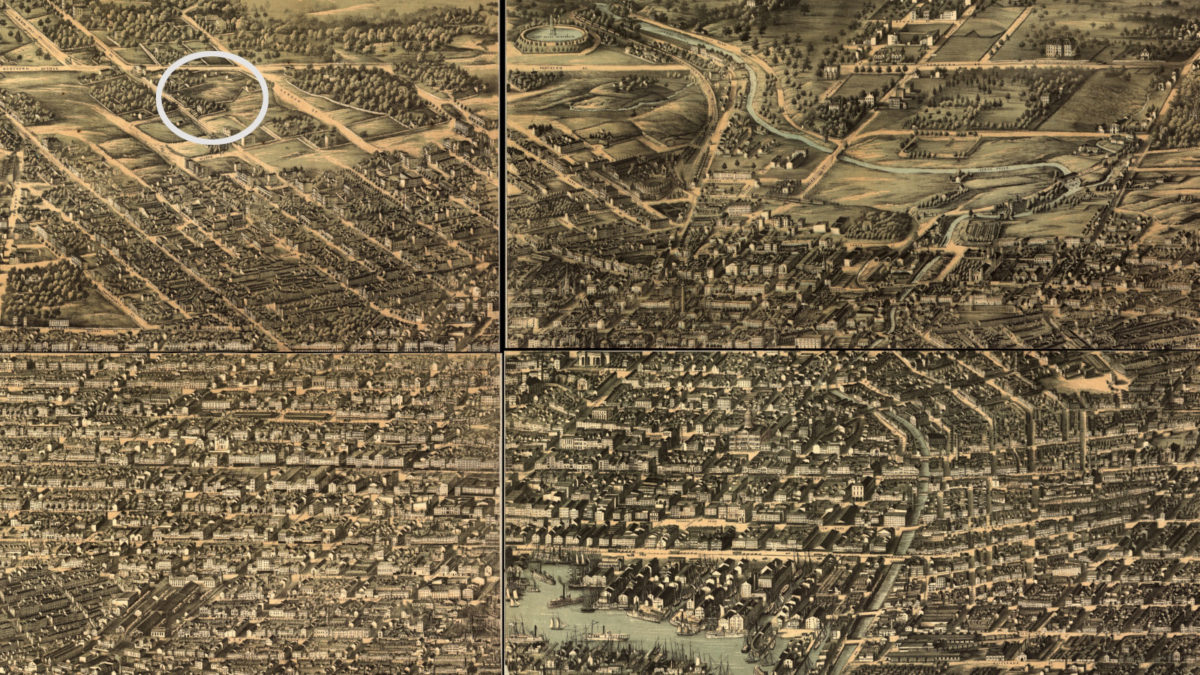
The Wikipedia article on the park has a little on who would have played here at the time, before professional baseball as we know it: “It was built by the Waverly Club as the first enclosed ballpark in Baltimore, with spectator seating and player clubhouses, and was the site of the first intercity game played in Baltimore (Brooklyn Excelsiors 51, Baltimore Excelsiors 6) on September 22, 1860; it was the site of a 47-7 defeat of the local Marylands by the undefeated Cincinnati Red Stockings in 1869, and it was used by the Washington Olympics for a professional game in 1871. On August 16, 1870, it was the site of an intercity game between black teams. It would continue to be used for games staged by black teams, in a time before there were any organized Negro Leagues.”
I think I could study this picture for days and never find everything. 🙂